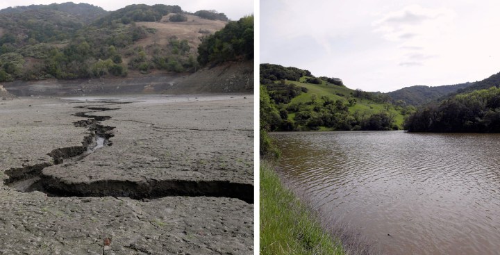
This post was published in 2014. On November 3, 2016 NBC Bay Area news reported Drought is Over in Nearly One-Fourth of California: Monitor, which featured before-and-after photos from AP with the caption:
This combo of two photos shows (left photo) the cracked-dry bed of the Almaden Reservoir on Friday, Feb. 7, 2014, in San Jose, Calif., and (right photo) the same Almaden Reservoir full of water on Monday, March 14, 2016. Four straight days of rain have replenished several key reservoirs in drought-stricken California.
Boom and bust weather pattern.
END UPDATE
Of course the climatologists are still trying to solve the puzzle, but the guess in the following report is worth keeping on file. I'm adding this observation, which is definitely not guesswork, from the report, even though it doesn't relate to causes:
"... most of [California's] infrastructure was designed and built during the 20th century, when the climate was unusually wet compared to previous centuries. That hasn't set water management on the right course to deal with long periods of dryness in the future."I assume the observation holds true for virtually all major U.S. cities. We are at the bottom of a very tall ladder that we need to scale fast. From National Geographic's February 13, 2014 report Could California's Drought Last 200 Years? by Thomas M. Kostigen
CLUES FROM THE PAST SUGGEST THE OCEAN'S TEMPERATURE MAY BE A DRIVER.
California is experiencing its worst drought since record-keeping began in the mid 19th century, and scientists say this may be just the beginning. B. Lynn Ingram, a paleoclimatologist at the University of California at Berkeley, thinks that California needs to brace itself for a megadrought—one that could last for 200 years or more.
[...]
What's causing the current drought?
Ingram and other paleoclimatologists have correlated several historic megadroughts with a shift in the surface temperature of the Pacific Ocean that occurs every 20 to 30 years—something called the Pacific Decadal Oscillation (PDO). The PDO is similar to an El Nino event except it lasts for decades—as its name implies—whereas an El Nino event lasts 6 to 18 months. Cool phases of the PDO result in less precipitation because cooler sea temperatures bump the jet stream north, which in turn pushes off storms that would otherwise provide rain and snow to California.
Ingram says entire lakes dried up in California following a cool phase of the PDO several thousand years ago. Warm phases have been linked to numerous storms along the California coast.
"We have been in a fairly cold phase of PDO since the early 2000s," says Brian Fuchs, a climatologist at the National Drought Mitigation Center, "so the drought we are seeing now makes sense."
That said, scientists caution against pinning the current drought on the PDO alone. Certainly ocean temperatures, wind, and the weather pattern in the Pacific have contributed to the drought, says Nate Mantua, of NOAA's National Marine Fisheries Service in Santa Cruz, California, where the PDO pattern was first discovered and named. "But it's more nuanced than saying the PDO did this."
After all, as its name suggests, the PDO is decades in the making.
[...]*********
No comments:
Post a Comment